

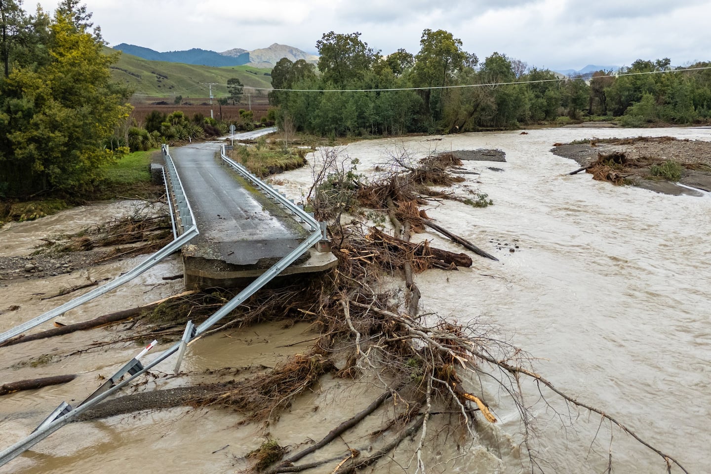
The Marlborough District Council is working to restore road access to two rural communities that were cut off during Tuesday’s flooding.
Marlborough Roads crews were out across the region assessing roads, monitoring flood levels, and clearing debris on Wednesday.
Marlborough’s first red rain warning had lifted, but a heavy rain watch remained in place in south Marlborough and north Canterbury until 6 pm Thursday. Marlborough Sounds would be under a strong wind watch from 6 pm Wednesday until 6 pm Thursday.
Recovery support was being provided to rural communities on Awatere Valley Rd and on Tyntesfield Rd in the Waihopai Valley, where floodwaters had severely damaged a bridge.

Marlborough Emergency Management incident controller Matt Kerr said at 4.02 pm that discussions were underway with both communities to understand their needs.
“Both of these communities are resourceful, but we are working with Marlborough Roads to ensure their access is restored as soon as possible,” Kerr said.
Mayor Nadine Taylor said support was also being provided to Kaikōura, which felt the brunt of the red warning event, experiencing two months’ worth of rain in just 48 hours.
“We are feeling for our close neighbours in Kaikōura who have felt the full force of this weather event,” Taylor said.
“We have offered our support and are pleased we can send some of the council’s building control staff to help out with rapid building assessments there.”
Taylor said her thoughts were also with Marlborough farmers and landowners who were faced with another cleanup. “Unfortunately, these severe weather events are becoming much more common these days”.
The council’s rivers engineers were happy with how the region’s flood protection had held up, and they expected river levels to continue to fall. Blenheim locals were urged to avoid the Taylor River Reserve and all floodwaters until water levels receded.

Marlborough’s emergency coordination centre hosted Emergency Management Minister Mark Mitchell on Tuesday.
“The minister spoke positively about the capability of Marlborough’s emergency response team and also the support we have been able to offer Kaikōura,” Taylor said.
NZTA confirmed at 4.29 pm that State Highway 1 between Ward and Kaikōura would reopen at 5 pm on Wednesday, but urged caution for drivers as the road “won’t be in the usual condition”.
State Highway 6 between McLauchlan St and SH1 had reopened at 3.35 pm.
The council urged drivers to exercise “extreme caution” when travelling on SH6 from the SH63 intersection north of Renwick through to the Rai Saddle.
State Highway 63 had reopened between Renwick and St Arnaud by 9:30 am, but remained closed between Howard Valley Rd and Kawatiri Junction. Work to clear fallen trees had continued with the hope of reopening the road in the afternoon or evening.
Drivers were urged to exercise caution on SH1 from Blenheim to Picton.
Queen Charlotte Drive between Havelock and Grove Jetty reopened after floodwaters receded. However, the road remained closed between Grove Jetty and Picton due to multiple slips.
Roads had reopened at Anakiwa Rd, Tapps Rd, Wakamarina Rd, Kaituna-Tuamarina Rd and Waikakaho Rd.
Kenepuru Rd was opened to one lane, with a slip at Ōnahau Bay partially blocking the road. Drivers were advised to exercise caution as there were other small slips along the road.
Port Underwood Rd was open to one lane, for 4WD vehicles only, after trees came down near Whatamango Bay. Crews were on site working to restore access, the council said.
Nine people were evacuated from a Blenheim holiday Park on Tuesday night due to flooding from the Ōpaoa River.
LDR is local body journalism co-funded by RNZ and NZ On Air.